Rasika Muthucumarana
Maritime Archaeologist
Maritime Archaeology unit – Central cultural fund – Galle – Sri Lanka
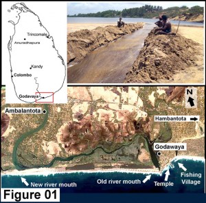
 Godawaya is a small fishing village, which belongs to the Hambantota district of Southern
Sri Lanka. It is situated between Ambalantota and Hambantota near the river mouth of the Walawe River, the fourth-biggest river of the country. This used to be the old river mouth, but with some changes happened in the coastal area and due to the massive sand deposits the river mouth was blocked many years ago. The river is now flowing to the sea from Ambalantota 3 km west to Godawaya. The mouth is blocked by a narrow sand strip, time to time it get cleared by floods or the villagers have to create an artificial outlet at the river mouth to divert the flooding. (Figure 01) The temple on a small rocky mountain near the left bank of the river mouth is known by many Archaeologists, historians and travellers because of its historical value.
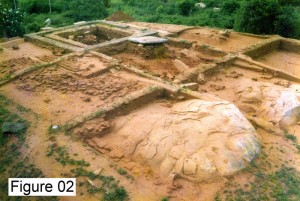
My first visit to Godawaya was in 1998, as an undergraduate who participated in the archaeological excavation at the temple premises. The excavation was conducted by the Archaeological Department of Sri Lanka and the German K.A.W.A. project. After a series of explorations and excavations from 1994, we were excavating the old image house area inside the temple. (Figure 02) A significant inscription found from this temple gives an idea about its history (Figure 03). A small and unclear inscription (No 01) and well-known inscription (No 02) found from this temple were first examined and reported by E.R. Ayortone in early 20th century. Later in 1930 professor Senarath Paranavitana read, prepared estampages and published these. (Paranavithana, S. 1983) The main and clear inscription carved on a natural
rock north to the Stupa state clearly about a seaport situated at Godawaya.
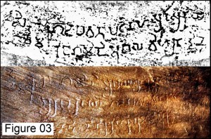
This inscription (No 02) consists of two lines, and the letters, which vary in height between 2 ½ in. and 6 in., have been clearly incised and regular in formation. These writings can be identified as belonging to the first or second century CE. (Paranavithana, S. 1983)
The record informs us that King Gamini Abaya (Gamani Abhaya) donated the customs duties of the port of Godapavata to the vihara at the site. The name Godapawatha, Gota pabbata or Godawaya means mountain with boulders (Gota – Short and round / Pabbata – Rocky Mountain). The Rocky Mount south to the temple is the highest place of this area. The small Stupa is built at the peak of this mount. From the sea, we can see the rock and the white stupa on it from miles away, which can be used as a landmark. Most probably the name Godapawatha can be a creation of early seafarers. The name Gamini Abhaya in the inscription can be identified as the king Gajabahu I, who ruled Sri Lanka in the 1st Century (113-135 CE).
The Text of the inscription No 02
1. Siddham Godapavata patanahi Su(ka) su(ri)yi
2. Raja Gamani Abaya viharata dini
Success! The customs duties of the port of Godapavata, King Gamani Abaya granted to the vihara (temple).
This is an excellent way to prove about the ancient temple, settlement and the seaport situated in Godawaya. This was not just a port; it was a developed and well-organized port, which was able to claim custom duties.
When the excavation team placed another new trench under the rock with the main inscription mentioned above, they found another completely new and well preserved three line inscription just one meter below the old one. (Figure 03) It is a separate inscription but in another way it also showed a continuation of the upper one. It also describes some of the donations to the temple.
Inscription No 03
1. Siddhama /* raja Gamani Abayaha rajika ahalaya bathika mithaye thini(ha kari)haka…
2. Arabapaya Godapavata viharata (dini) ethahi (Javaha)ka vihakalanakara(ka)
3. Kethahithinikarihaka bumi dine (symbols) nakaraka chethahata dine (symbols)
According to Dr. Piyathissa Senanayaka, who inspected the inscription at the site, this is the rough meaning of the text.
Success! Ahalaya bathikamithaya, the Queen of the King Gamini Abaya granted three Karisaka (twenty-two acres) of land to the Arabapaya Godapavata vihara (Temple). At the same time another three Karisaka (twenty-two acres) of land from the paddy field of the Jawahakavilaka city to the Stupa.

During the last two decades many explorations and excavations took place in and around the Godavaya temple. Through these researches many archaeological information related to the old port and its international trade relations were found. From an excavation that took place in front of the fishing village part of an old maritime structure was found. (Weissharr, H.J. / Wijeyapala, W. / Roth, H. (ed.) 2001) It looks like a part of a jetty or a bridge build with stone pillars, which are very similar to the stone pillars found from the old image house of the temple. (Figure 04) If we observe from the temple, the river is flowing to the sea from right side and the fishing village (Bay of Godavaya) is at the left side. Both of these places can be parts of the seaport. In one hand the Bay of Godawaya, the beach with the stone pillars and fishing village is the safest landing place of the area. On the other hand the river mouth and the wide sluggish river was also an appropriate way for transportation. Unloaded cargo from the vessels would have been transfered in to the country using boats and Barges. The Walawe River is flowing through ancient settlements and monastic sites such as Ridiyagama, Mahanavulu pura and Ramba monastic complex. There are records of coins, mainly thousands of Indo-Roman coins found from private lands and paddy fields near the riverbanks. (Bopearachchi,O. 1996)

In 2003 an old stone anchor was found from the sea near the fishing village. (Figure 05) The fishermen who found the anchor gave it to the research team. In the same year, when we (Maritime Archaeology Unit) went to see the temple and the excavation project, the Archaeologists (Professor Helmut Roth and Mr. Oliver Kessler) asked us whether there was a possibility to do an underwater exploration at the Godavaya. But at that time we were engaged with some other work in Galle harbour and weren’t ready to do anything outside that. We only managed to record the stone anchor and the surrounding environment.
It was a triangular shaped anchor fully made with Granite stone, and had a hole in the middle. More like the stone anchors found from the Galle harbour exploration. All were made of stone, but the material types were different. Godawaya anchor was more solid and heavier than those found from Galle. According to the records these types of stone anchors were used during the pre-colonial period, especially with the indo Arabian and Chinese vessels. (Maritime Lanka web site)
In the following year two local divers from Godavaya found another valuable item related to this story. Sunil and Peminda who lived near the Godavaya temple were well-experienced divers making their living by collecting Conchs and colour fish. Not like the most local divers, they are well trained and work with some sense. One day when they were diving in to the deep for shells, they found an area with potshards. They noticed some big parts of clay jars and some strange objects scattered all over that area. From that site they found a small stone object, which was more similar to a small bench (Figure 05). They brought it with them and marked the location of this unusual place on their GPS. The bench was handed over to the excavation project and was stored at the Tissamaharama storeroom, under the Department of Archaeology. But no one knew where the site was (except those two divers) and that incidence and the bench was forgotten with the time.
The second phase of the UNESCO regional field school program for maritime archaeology was held in Galle and ended in April 2008. At the end there was a need of finding a shipwreck with Asian origin to use for training activities for the next field school session. In October 2008 we started an exploration with the funds from UNESCO Bangkok office to find some new suitable sites for future fieldwork. Under the instructions of Dr. Mohan Abeyratne (Deputy Director General – Central Cultural fund) a team of maritime archaeologists and conservators set off for south coast. Our main targets were the wrecks around the famous Great Basses reef and the possible wreck site near the Godawaya.
After the exploration at the Great basses we came to Godavaya. During the exploration at Great basses we had time to collect and investigate the data related to the Godawaya. The Stone bench and the stone anchor were carefully investigated. Met the two conch divers and tried to get as much information as possible. According to them the site was at 30-meter depth and 03 kilometers away from the coast. There was no possibility to find potsherds and artefacts like the stone bench from that area unless there had been a Shipwreck. On the flat side of the bench we found some symbols, which belonged to very early periods.
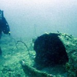
On 18th October following the directions of those two divers, we did our first dive over that site. When we reached the seabed, 31 meter was indicated on our depth gages. We saw some mounds made with corals and sea plants on sandy bottom. The bottom was bit dark and cold. When we were searching this area we found some potsherds in the seabed among those reefs. We didn’t have much time to spend, because the divers were using only one air cylinder and at the 30-meter depth we were only able t spend around 20 minutes.
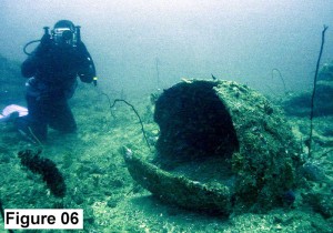
On the following day we carried out the exploration in more systematic way. Three buddy pairs searched the site separately and collected data and filmed the area. At the end of the twenty minutes the team re-united on the boat. What we found that day was tremendous. Under the mounds, which we thought were reefs, we found some timber sections. Those very fragile wooden parts were covered with thick layer of corals and plants. These were scattered over an about 100 square meter area. Between and around two large mounds there were lots of potsherds (Figure 06). Other than the potsherds, we found some complete and near complete jars. Some were huge and camouflaged with the environment. If the seabed was interrupted with strong currents these potsherds wouldn’t have been like this. This was a clear sign that the site was undisturbed and settled as it is. But it was not easy to understand the site formation, and weren’t able to identify any parts of ship’s constructions. Apart from the potsherds we found some glazed ingots, which were used to glaze or colour the clay pots.
Next few days spent to record the site and explore more. We also brought out some artefacts for further investigations. After cleaning the potsherds and jars we brought, they were all identified as BRW (Black & Red Ware). We found some big fragments more similar to the Amphora and some small rare types of plates and bowls (Figure 05). After five days we had to stop our site work due to the sudden changes of the climate and due to some strong surface currents, which started to flow just above the site.
If we compare this site with other underwater archaeological sites found so far in Sri Lanka, this is definitely a significant site. According to the analyses we did so far with the artefacts they should belonged to an era before the 4th Century CE. This is the minimum general boundary for the Black & Red Ware. BRW can be traced up to the 20th Century BCE. (De Silve N., Dissanayake R. B., 2009) Also some of the symbols on the stone bench were used between 3rd and 1st Century BCE.
The site and the artefacts are being investigated and carefully recorded again. We are hoping to identify and record the wooden parts to get an idea about the vessel and its constructions. Still we don’t have a correct evaluation about the area of the wreck site. We need to carryout a careful exploration around the main site to look for some more remains. It can be larger than what we expect and may extend under the sand.
Reference:
- Bopearachchi,O. 1996, Seafaring in the Indian Ocean. Archaeological Evidence from Sri Lanka, in: Ray/Salles 1996, 59-77.
- Bopearachchi, O., 1993. Indo-Greek, Indo Seythia and Indo Pathian; coins in the Smithsonian Institution; Washington.
- De Silve N., Dissanayake R. B., 2009. A Catalogue of Ancient Pottery from Sri Lanka., (PGIAR) Post Graduate Institute of Sri Lanka, Colombo.
- Paranavithana, S. 1970. Inscriptions of Ceylon, Vol. I. Containing cave inscriptions from 3rd cheap viagra century B.C. to 1st century A.D. and other inscriptions in the early Brahmi script (Colombo).
- Paranavithana, S. 1983 Inscriptions of Ceylon, Vol.11, part 1.Containing Rock and other Inscriptions from the Reign of Kutakanna Abhaya (41 B.C.-19 B.C.) to Bhatiya II (140-164 A.D.).Archaeological Survey of Ceylon, Colombo.(Moratuwa)
Weissharr, H.J. / Wijeyapala, W. / Roth, H. (ed.) 2001 Ancient Ruhuna. Sri Lankan-German Archaeological Project in the Southern Province., Vol.I., KAVA Institute, Bonn.
Maritime Lanka Website – www.hum.uva.nl/galle/site/books.html
Photo credits
Figure 01 – Sanath Karunaratne
Figure 04 – Department of Archaeology/ KAWA Project
Figure 02, 03, 05 and 06 – Rasika Muthucumarana
cialis 50mg[/fusion_builder_column][/fusion_builder_row][/fusion_builder_container]


pls check this out.., how tmailnet is use this article for their benifits.. pls take necessary action without delay..
http://www.tamilnet.com/art.html?catid=79&artid=32626
Why is Gamani Abhaya identified with Gajabahuka Gamani, apart from his wife’s name? The Mahavansa mentions that Gajabahu’s father in law Mahallaka Naga built the Gotapabbata Vihara, so any gift would have to be after that, which would tend to rule out Gajabahu. The next Abhaya we have is Abhaya Naga, a century later and the next is Gotabhaya a quarter century later.
Yes Bandara, I took have seen that website but I doubt the Sri Lankan Archaeology dept, has the courage or strength to take on the Tamil extremists propaganda machines!
මීට ටික දිනකට ඉහචටà·à¶¸à·’ල්නෙට් අඩවියේ ගොඩපවචසෙල්ලිපිිය පිළිබද විස්à¶à¶»à¶ºà¶šà·Š ඉදිරිපà¶à·Šà·€à·”නි. ගොඩපවචයන නම දෙමළ නමක් බවà¶à·Š වරà·à¶º අවට පâ€à·Šâ€à¶»à¶¯à·šà·à¶ºà·š දෙමළ ජනය෠විසු පâ€à·Šâ€à¶»à¶¯à·šà·à¶ºà¶šà·Š බවà¶à·Š ලිපිය ලියු ඊළà·à¶¸à·Šà·€à·à¶¯à·’ය෠සිà¶à¶ºà·’. මේ සදහ෠සිංහල සෙල්ලිපියේ වචන සමග නොයෙක් සෙල්ලම් දරන ඔහු ගොඩ යනු කà·à¶©à·” යන දෙමළ වචනය බව කියයි. එය කියවු විට ඊලà·à¶¸à·Š පොර අර මොකක්ද ගොඬේ එරී ඇà¶à·’ à·„à·à¶§à·’ පෙනේ.
සෙල්ලිපිය මෙයයි.
Siddham Godapavata patanahi Su(ka) su(ri)yi
Raja Gamani Abaya viharata dini
යහපà¶à·Šà¶šà¶¸ ඉටුවේවà·à·Ÿ ගොඩපවචපටනහි සු(ක) සු (රි)යි රජ ගමිණි අභය විහරට දිනි. (සිද්ධම් යනුවෙන් මෙහි දà·à¶šà·Šà·€à·™à¶±à·Šà¶±à·š සෙල්ලිපිය කරවු රජà¶à·”මà·à¶œà·š පâ€à·Šâ€à¶»à·à¶»à·Šà¶®à¶±à·à·€à¶ºà·’. රටට à·à·à·ƒà¶±à¶ºà¶§ ජනà¶à·à·€à¶§ හොදක් ම වේව෠යනු එහි අරුà¶à¶ºà·’. (ගොඩපවචපටුනින් (වරà·à¶ºà·™à¶±à·Š උපයන රේගු බදු ආදà·à¶ºà¶¸ මෙහි විහà·à¶»à¶ºà¶§ හිමිවියයි යුà¶à·”යි ගà·à¶¸à·’ණී අභය රජà¶à·”ම෠නියම කර සිටී).
මම සෙල්ලිපිය හම්බන්à¶à·œà¶§ දිස්à¶â€à·Šâ€à¶»à·’ක්කයේ මà·à¶œà¶¸à·Š පà¶à·Šà¶à·”වේ ගà·à¶¨à¶´à¶¶à·Šà¶¶à¶ විහà·à¶»à¶ºà·š ගලක කොට෠ඇà¶à·Šà¶à¶šà·’. ඉංගීâ€à·Šâ€à¶»à·ƒà·’ පà·à¶½à¶± සමයේ විසු ඊ. ආර් අයර්ටන් (1912 1914) පුරà·à·€à·’ද්â€à¶ºà·à¶¥à¶ºà· විසින් සොයà·à¶œà·™à¶± ලේඛන ගචකරන ලද්දකි. පුරà·à·€à·’ද්â€à¶ºà·à¶¥ සෙනරà¶à·Š පරණවිà¶à·à¶± මහà¶à· විසින් කියව෠1930 දී එà¶à·”ම෠සකස් කළ සෙල්ලිපි සංගâ€à·Šâ€à¶»à·„ය යටà¶à·š පà¶à·Šà¶šà¶»à¶± ලදි. සෙල්ලිපිය පිහිටවු ගà·à¶¸à·’ණී අභය රජà¶à·”ම෠සිංහල ඉà¶à·’à·„à·à·ƒà¶ºà·š ගජබà·à·„à·” (113- 135) රජà¶à·”ම෠වà·à¶ºà·™à¶±à·Š පà·à·„à·à¶¯à·’ලි කරන්නේද පරණවිà¶à·à¶± මහà¶à· ම ය.
ගජබà·à·„à·” රජු ජිවà¶à·Š වු කà·à¶½à¶ºà·š ගොඩපවචවරà·à¶º පිහිට෠à¶à·’බුණේ වලවේ ගග මුහුදට à·€à·à¶§à·™à¶± ස්ථà·à¶±à¶ºà·šà¶º. පසු කලක ගගේ සහ ගං මුවදොරේ වෙනස්වීම සිදුවීම නිස෠පà·à¶»à¶«à·’ ගොඩපවචවරයà·à¶§ එහà·à¶ºà·’න් දà·à¶±à·Š ගග මුහුදට à·€à·à¶§à·™à¶±à·Šà¶±à·š. මෙම විà·à·à¶½ ගංගà·à·€ ආà·â€à·Šâ€à¶»à·’à¶à·€ පුරà·à¶±à¶ºà·š සිංහල යුවරà·à¶¢à¶°à·à¶±à·’ පව෠ගොඩනà·à¶‚වී පà·à·€à¶à·”නි. ගොඩපවචවරà·à¶ºà·™à¶±à·Š විදේ෠වෙළදà·à¶¸ පව෠සිදුවු බව ගොඩපවචසෙල්ලිපිය මගින් ඔප්පුවේ.
ඊලà·à¶¸à·Šà¶šà·à¶»à¶ºà· ගොඩපවචයන්නට දෙමළ අරුà¶à·Š සපයන්ඩ ගොස් එරෙන්නේ ගොඩපවචයන්න දෙමළ කිරිමට යà·à¶¸à·™à¶±à·’. මෙය විහà·à¶»à¶ºà¶š පිහිටුව෠ඇà¶à·’ සෙල්ලිපියකි. ගොඩපවචයයි මෙහි සිංහල සදහන ගොඨපබ්බචයන පà·à¶½à·’ නමේ අරුà¶à¶ºà·’. ගà·à¶¨ (කොට) පබ්බච(පර්වà¶à¶º). පà·à¶½à·’ය අනුව ලේඛන භà·à·‚à·à·€à·™à¶±à·Š එසේ නමුදු à·ƒà·à¶¸à·à¶±à·Šâ€à¶º ජනවහර අනුව ගà·à¶¨ පබ්බචවිහà·à¶»à¶º යන්න කොට කන්ද විහà·à¶»à¶º à·€à·à¶ºà·™à¶±à·Š පරිවර්à¶à¶±à¶º කිරිමට පුලූවන. (ගà·à¶¨) කොට (පබ්බචවිහà·à¶» ) කන්දේ විහà·à¶»à¶º ලෙසිනි.
එද෠ඈචමුහුදේ සිට එන යà·à¶â€à·Šâ€à¶»à·à·€à¶½à¶§ කොට කන්ද පන්සලේ දà·à¶½à·Šà·€à·™à¶± පහන් අà¶à·’à·à¶ºà·’න් පâ€à·Šâ€à¶»à¶ºà·à¶¢à¶«à·€à¶à·Š වෙන්ට ඇà¶.
Why the Archaeology Department cannot reply to Tamil Net fiction is because the Archaeology Department does not have internet connections and appears not to have working email addresses. Even the email address of the Director General does not work.
Susantha Goonatilake
I read somewhere these artifacts have been further studied
and carbon dating done. Could you please post those facts here if they are true.
Comments are closed.